Thursday, December 10, 2009

Telluride Waterfall Hikes

The hiking in the Telluride, Colorado area features several waterfalls as destinations. The mountain views are spectacular. There are also mining ruins and ghost towns to find and the forests are thick and lush.

The Bridal Veil Falls is probably the most famous of the Telluride Waterfalls. The steep switchback road starts at the east end of town at the end of the Idarado Legacy Trail. At the top of Bridal Veil Falls is an historic power plant that has been refurbished and is operating.
Further up the switchback road to Black Bear Pass in Ingram Falls. The 4WD route starts at about 9000 feet of elevation and climbs to over 10,000 feet. The view here is from the Tomboy Road Trail leading to one of the mining ruins sites.

Visiting Cornet Falls is the shortest hike, only 0.25 miles. The trail head is the same as the west arm of the Jed Wiebe Trail at the north end of Aspen Street. There is a series of two falls here, with the further one the most interesting.
The Bear Creek Falls Trail is a popular 2.2 mile hike on the south side of Telluride at the south end of Pine Street. This hike is so locally popular that it draws joggers not bothering to carry water bottles, just a morning workout.

Another waterfall in the area is the Bilk Creek Falls in the nearby Lizard Head Wilderness. The long way to this falls is to start at the Cross Mountain Trail Head, about two miles south of Lizard Head Pass, south of Telluride. Taking this route will pass by the top of the falls, but it is a long hike. The shorter hike is to follow the Sunshine Mesa Road to the Wilson Mesa Trail, then follow the Lizard Head Trail to the base of the falls.


18407_$5 Shipping on Orders of $99 or More! 528669_Russell Womens Fleece Hoodie Banner

Tuesday, August 18, 2009

Blixt Trail toward Oscar’s Pass-Ophir

The Blixt Trail starts as a side road off of the Ophir Pass Road in southwest Colorado. Ophir is a mountain hamlet in a scenic canyon south of Telluride and east off of Highway 145. The Ophir Pass Road is one of many spectacular high mountain 4WD routes in the Telluride area.


The Ophir Canyon has many obvious signs of past mining activity. I started my hike just past the last group of houses in Ophir where the Ophir Pass Road starts to get rough and the elevation is about 9800 feet. About 1.5 miles further along the road, the second of two side roads on the left leads uphill for 0.4 miles or so to a green gate. The gate ends all motorized travel.

There aren’t any signs that advertize the trail. A good map is advisable. The trail past the gate is the remains of an old road that leads steeply uphill to Oscar’s Pass and the Bridal Veil Basin. The trail is eroded in places and the surface is mostly large gravel. The steepness and the gravel combine to make the descent the type where my feet start to skid and slip out from under me. I hiked the first 1.5 miles to the turnoff but it is drivable in a high clearance vehicle.

As the trail climbs, there are higher and higher views up and down the Ophir Canyon, including high angle views of the Ophir Pass Road. The pass road is also a good hike, easier than this one. The road appears to be very narrow and the traffic I could see was moving very slowly. There seemed to always be a vehicle in sight, sometimes several.

Back to the west there were views down into Ophir and the mountains beyond. The Lizard Head was visible in the distance. On the way into Ophir, there are rock climbing opportunities. I saw a mountain school van stopped by the Ophir Needles, near the junction with Highway 145. There is also a somewhat comical closet sized Post Office along the way.

I didn’t make it to the top of Oscar’s Pass. I hiked for 2:20 hours and got to a point a couple of hundred yards short of the final switchbacks. I think I got as high as 12,500 feet but needed about another 1 mile of walking and 600 more feet of elevation to get to the top. There are two lakes in the basin above including Blue Lake that can also be reached from the top of Bridal Veil Falls east of Telluride.

There isn’t very much posted on-line about the Blixt Trail. I found a short report with some short videos posted by an Ultra-Marathoner. I suppose this was an easy hike for him, but the relentless steepness was too much for me. His hike was in early July and there were still large patches of snow in the highest area. I didn’t see any snow above in mid August.

About 0.5 miles below my turn around there was an apparent trail junction, with a westward leading trail crossing a scree area. The map I had made it appear that this route would loop back down to Ophir. I crossed the scree area, with good views to the area where I had just hiked, but this route started to climb again, and I didn’t want to do any more climbing. I returned by retracing the route up.

My total hike was 4:30 hours for about 7.5 miles. The temperature was about 60 F degrees at 10:00 AM. It felt cooler and there was some wind at my highest point 2 hours later. It was a blue sky day with no thunder clouds. I carried 3 liters of water.

On the way to Ophir I saw two moose with antlers cross Highway 145 from west to east a little south of the Matterhorn Campground. Several cars slowed to let them cross and they hurriedly and awkwardly dived into the brush. These were first moose I’ve spotted in this area.


Thursday, August 13, 2009

Calico National Recreation Trail- North Trailhead

The Calico National Recreation Trail runs south from the south edge of the Lizard Head Wilderness for 19 miles high along the west side of the upper Dolores River in southwest Colorado. At the north end of this long trail there is a system of trails that offer several loop opportunities.

The Winter Trail starts at the same trail head, about 1 mile south of the very scenic “Meadows” area along the Eagle Creek Road, FR 471. The trail climbs steadily for 5 miles through  Spruce and Fir forest with a few aspens and scattered meadows. As the trail rises there are glimpses of Mt. Wilson, El Diente and the iconic Lizard Head back to the north.

The best views that I have found in this area south of Telluride are along the portion of the Calico Trail going over the top of Papoose Peak at 11,866 feet. The tall spruce trees give way to open rocky meadow and the views are unobstructed. All the mountains from Lone Cone to the west, across the Lizard Head Wilderness, over to the group at the Lizard Head pass are visible in one sweeping view.

I had to find a seat here and have lunch to prolong the experience. I was interested to spot the areas where other trails run. I could see the area below Lizard Head Peak where the Cross Mountain and Lizard Head Trails connect. The terrain that the Ground Hog Stock Trail covers could be easily viewed. Over to the west the Willow Divide and Black Mesa stood out.

Continuing on, the Calico Trail skirts high along the west side of Elliott Mountain. This section of trail felt a little exposed as the slope is steep on the downhill side. Below, there are glimpses of Eagle Creek Road and the East Falls Creek Trail. Up ahead is Sockrider Peak.

There are several options at the north end of Sockrider Peak. There is a loop route that circles Sockrider, and another loop option further on, but the distance will get much longer for a hiker. The trail signs direct horses and dirt bikes to stay on the west side of Sockrider while hikers can take the east side.

 I stayed to the west and continued downhill to the nearby junction with the East Fall Creek Trail. The East Fall Creek Trail descends rapidly down through the forest and turns back north with a few views to the west.

It is 1.5 miles along the East Fall Creek Trail to the Eagle Creek Road. At the junction with the road I turned back toward the trail head, another 5.5 miles. This is the shortest loop option. It took me 3:00 hours to cover the 5 miles to the East Fall Creek Trail junction and another 1:00 hour to get to the Eagle Creek Road.

The walking along Eagle Creek Road is easy and the road is lined with tall spruce. There are a few views but not as spectacular as above. My total hike was 6:00 hours for about 12 miles. It was about 60 F degrees at 10:00 AM and windy enough at the high elevations that I needed a second layer. At 2:00 PM along the forest road it was about 75 F degrees. I carried 3 liters of water.

528669_Russell Womens Fleece Hoodie Banner

Tuesday, August 4, 2009

Bilk Creek Falls Loop Trail

The Bilk Creek Falls Loop Trail uses segments of the Lizard Head Trail and the Wilson Mesa Trail and an old mining road on the northern edge of the Lizard Head Wilderness near Telluride in southwest Colorado. The trail head is at the south end of Sunshine Mesa Road.

Sunshine Mesa Road connects to the South Fork of the San Miguel Road and starts out straight, wide and smooth as it climbs. This lower road segment is a part of the Galloping Goose Trail that runs about 21 miles north from Lizard Head Pass and connects to the Telluride Valley Floor Bike Trail. After the point where the Galloping Goose Trail branches off and becomes a single track trail, the Sunshine Mesa Road becomes narrow, rough and twisty with a few mud holes before arriving at the trail head.


The signs at the trail head say Wilson Mesa Trail and 2 miles to the Lizard Head Trail and Bilk Creek, though practically speaking this is the trail head for the Lizard Head Trail also. The trail head elevation is about 9760 feet. About 0.8 miles along this wide and smooth segment, the Wilson Mesa Trail turns west and the old mining road continues south. I continued south on the old mining road as it is the shorter route to the Bilk Creek Falls, but a hiker can choose either route.

The old mining road stays on the east side of Bilk Creek and is mostly in deep Engelmann Spruce and Aspen forest with a few views to the flanks of Wilson Peak. Just before the mining site the trail crosses Bilk Creek. When I hiked there was a hiker arranged log and plank bridge to aid the crossing.

The mining ruins site is notable in that somehow a large red tractor trailer had been pulled in there. Quite a bit of old hardware is inside the trailer and scattered around the site. About 0.5 miles past the mining ruins site, the Bilk Creek Falls start to come into view.

The falls is a series of falls and cascades. The forest is thick and the falls has carved a steep rocky chute I didn’t see an easy way to get close for a good view. The trail switch backs up the slope and there are higher views but no close ones.


I climbed the trail until I was near the same elevation as the top of the falls, about 10,400 feet. The trail continues up into Bilk Basin and then continues on toward the base of Lizard Head Peak. I hiked for 1:50 hours before turning around.

On the return hike I took the longer Lizard Head Trail segment to complete the loop. The trail junction is at the old mining site and the Lizard Head route is clearly marked. If you took this longer route first the old mining road on the other side of the creek might not be noticed and there isn’t a sign pointing it out.

The Lizard Head part of the loop stays on the west side of Bilk Creek for about 2 miles and passes through meadow areas offering some views to the north. There is another small falls a short distance below the main falls. The Lizard Head Trail officially ends at a trail junction with the Wilson Mesa Trail and it is another 3 miles back to the Sunshine Mesa Trail Head, climbing through forest back to the old mining road.

The return crosses a level section of Bilk Creek over a foot bridge that is falling into disrepair but is still useable (but missing by 2011). There might be some beaver ponds along this section of Bilk Creek. My total hike took 4:30 hours for about 9 miles using the loop route. The minimum hike to see the Bilk Creek Falls would be about 5 miles. It was about 60 F degrees at the trail head at 10:00 AM on an early August partly cloudy day. I carried 3 liters of water but only drank 2.


528614_Russell Outdoor Logo 125x125

Tuesday, July 28, 2009

Cross Mountain and Lizard Head Trail to Bilk Basin

The Cross Mountain Trail provides access to the middle part of the Lizard Head Trail in the San Juan Mountains in southwest Colorado.


It is about 3 miles with about 2000 feet elevation gain to reach the trail junction at the base of the iconic Lizard Head peak formation. A right turn heads east toward the Lizard Head Pass. A left turn heads north and descends into the very scenic Bilk Basin.

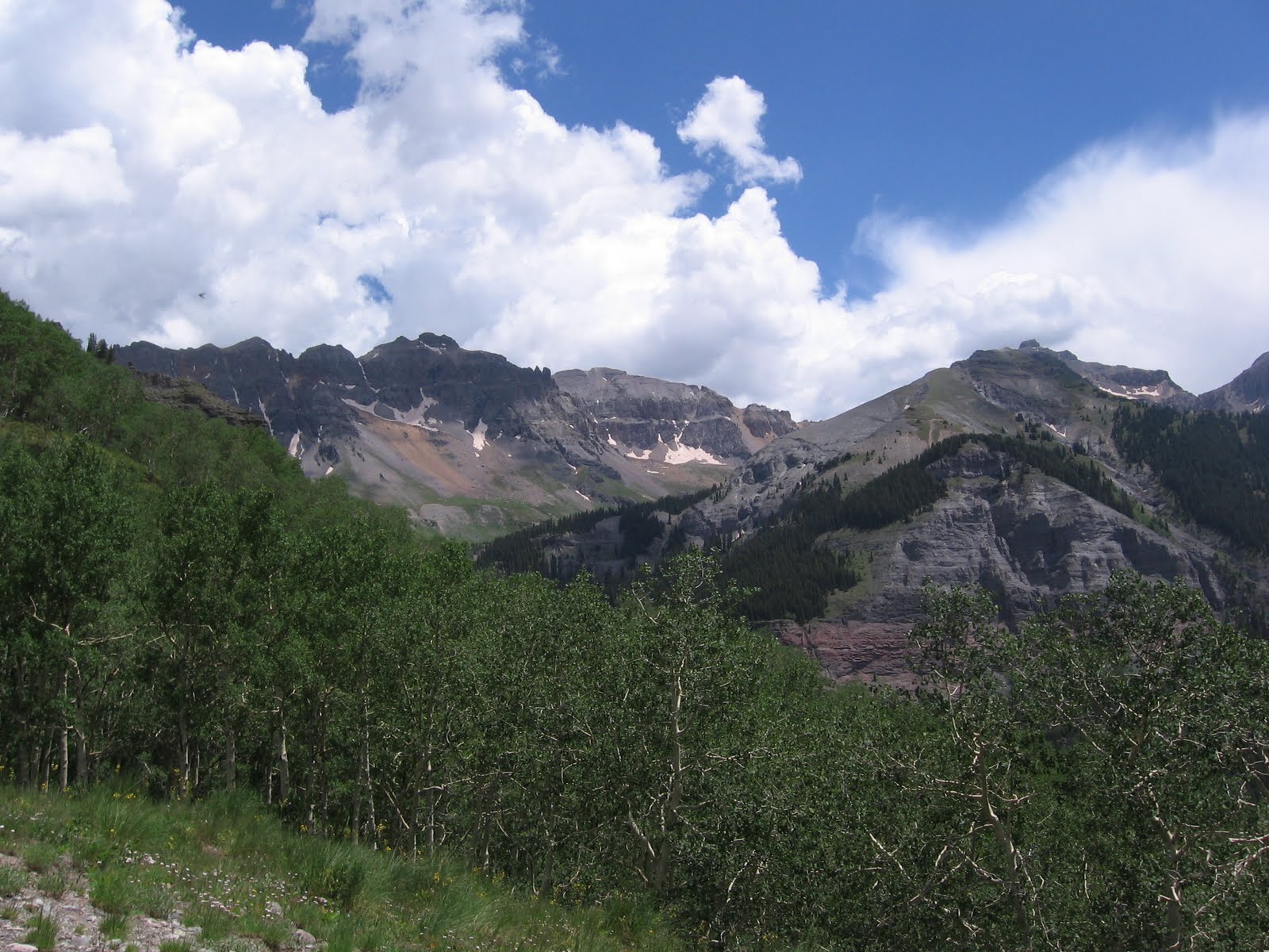
The Cross Mountain Trail Head is about 2 miles south of the Lizard Head Pass and south of Telluride along Highway 145. The starting elevation is about 10,000 ft. It took me about 2:00 hours of steady climbing to get to the trail junction. For the most part the trail passes through Engelmann Spruce forest, emerging into a tundra like area rich with wildflowers and wide views.

Starting the gradual descent into Bilk Basin I noticed a large herd of elk also heading for the basin across the shoulders of 12,703 ft. Cross Mountain. The herd of about 70 hesitated at the crest of the shoulder, seemingly because of me and another hiker and then turned and went back the way they had come, their plan for the day disrupted despite a seemingly safe distance.

The Bilk Basin is surrounded by high peaks on all sides with several creeks converging along the way and flowing north. The west side peaks include Gladstone Peak at 13, 913 ft. and Wilson Peak at 14,047 ft. Wilson Peak has an old road switch backing up the face that was access for old mines and now is a side trail off the Lizard Head Trail.

The trail descends down and crosses Bilk Creek and climbs the opposite shoulder. Looking back, from the Bilk Basin angle the Lizard Head looks more like a lizard head than the usual views of it. Just after crossing the creek there is a large rock cairn at a vague trail junction on the left and there is another smaller cairn further on. The maps of this area mention a falls and that was my goal.

Looking down the basin there are some signs of development in the distance. There is a trail head for this area ahead on Sunshine Road and some roads and small buildings are visible. In late July the wildflowers in Bilk Basin are very rich, fed by small streams flowing down the mountain sides.

The trail crosses a cascade of water tumbling down through the scree slopes and I stopped here, about 0.5 miles before the more spectacular Bilk Basin Falls. It had taken me 3:30 hours to get here and the trail crossing here looked a little tricky. The crossing is only about 4 feet wide but the water is flowing very fast and may involve a step that gets you wet up to your knee. The elevation at the cascade is about 11,100 feet and it is a climb of about 900 ft. back to the Cross Mountain trail junction.

It may be possible to bypass the cascade crossing and rejoin the trail by picking a route down through the forest and crossing the creek where the slope is more gradual. There seems to be a trail post a few hundred yards before the cascade that may mark an alternate route. The falls below are supposed to have a 300 foot drop.


My return hike took 2:40 hours for a total of 6:40 hours for about 9.6 miles. It was about 55 F degrees at the trail head at 9:00 AM in late July and got windy enough at the base of Lizard Head that I had to add a layer though it was still about the same temperature. It was about 70 F at the trail head at 3:50 PM when I finished. I carried 3 liters of water.


Tuesday, July 14, 2009

Tomboy Trail

The Tomboy Trail is a popular 4WD road that climbs toward the east along the north side of Telluride Canyon in southwest Colorado.


Five miles along the trail is the Tomboy mining ruins site and further is Imogene Pass and Ouray. The beginning of Tomboy Road is at the north end of Oak Street in Telluride.

I started my hike from the free parking area on the southwest side of Telluride and walked through the town streets a few blocks to Oak Street. There isn’t any parking at the intersection of Tomboy and Oak.

Tomboy Road is also the access for the east end of the Jud Wiebe Trail, a popular 2.7 mile loop that takes about 2 hours to hike. Climbing past the Jud Wiebe Trail Head, there are increasingly higher views toward Bridal Veil Falls and Ingram Falls at the east end of the Telluride Valley.

 The trail is a single lane rocky road with frequent wide spots. The surface is mostly easy to walk on and is steep but not as steep as mountain trails can sometimes be. There were quite a few commercial mountain tours going up the trail and several rented jeeps.

I saw three other hikers and no mountain bikes. The views are mostly open and the Aspen and Spruce forest is not noticed as much as usual. In mid July there are many wildflowers in bloom including some Columbines.

During the first half of the hike, Bridal Veil Falls, on the south side of the valley is frequently in view. The hike to Tomboy rises above the elevation of that also popular destination. There is one spot along Tomboy Road where Bear Creek Falls, Ingram Falls, and Bridal Veil Falls are all in view at the same time.

One interesting feature of this route is the short tunnel cut through the rock. After the tunnel, the trail is more level for about a mile and the main Telluride Valley goes out of sight. About one mile before the main Tomboy mining site, some outlying mining ruins start to appear.

The mining ruins along the Tomboy Road appear to be more devastated than one might expect. Another popular ghost town in the area is Alta, where the old buildings appear to be better preserved. There is an interpretive sign at the Tomboy site that says the town had a school, stores, stable and miner’s cabins. The mines started producing gold ore in 1894 and are 3000 feet higher than Telluride at about 11,800 feet.
The main Tomboy site looks like it was hit by tornados, a large scatter of debris without much standing. The surrounding area though is very scenic. It took me 3:00 hours to arrive at the Tomboy site and a quicker 2:00 hours to descend. With stops, my total hike was 5:30 hours for a little more than 10 miles. It was a mid 60s F day, partly cloudy with a few drops of rain. I carried and drank two liters of water.


Tuesday, July 7, 2009

Deep Creek Trail and Cornet Falls

The Deep Creek Trail travels for about 13 miles along the north side of the Telluride Valley in southwest Colorado. The east trail connection is along the western loop of the Jud Wiebe Trail. The Deep Creek Trail is part of a large trail system that offers several hiking options.

I started my hike from the free parking area on the southwest end of town and walked a few blocks through the pleasant streets of Telluride to the Jud Wiebe Trail head at the north end of Aspen Street. There doesn't appear to be any parking in the trail head area. At the trail head there is also a short trail leading to the Cornet Falls.

The Jud Wiebe Trail is a popular 2.7 mile loop back to the east. The first 0.8 miles of Jud Wiebe climbs steeply to the west and arrives at the east end connection of the Deep Creek Trail. Another 100 feet along the Deep Creek Trail there is a connection with the east end of the Sneffels Highline Trail that heads further north. It’s good to have a map of this trail system when hiking up here.

The Deep Creek Trail levels out and moves west offering high elevation views of the Telluride Valley. After about a mile it turns away from the valley and loops around the Mill Creek area eventually crossing a small bridge over a roaring plunging stream.

Along the trail there are old pipes and other artifacts from the mining era. High above Mill Creek a large waterfall is visible but the views are obscured by the thick forest. In this area the forest is Aspens, Douglas Firs and Engelmann Spruce.

Past the bridge, there is an access trail connecting to the Mill Creek Road leading back down to the valley floor. After the access trail junction, the trail begins climbing again for 2 miles to the western junction with the Sneffels Highline Trail. The trail signs indicated that the Sneffels loop is 8.2 miles back to the east connection with the Deep Creek Trail.


There are some meadow areas along this segment with great views of the mountains that lie north of the Telluride Valley. Wildflowers are moderately good along the whole length of the hike here.

I got a tip from another hiker that about 10 minutes north on the west connection of the Sneffels Trail there is a large rock outcrop giving great views in several directions. This rock outcrop appears to be a popular local destination. Besides views into Telluride Mountain Village and the mountains beyond, you can see a little into the Sneffels Basin to the north.

From this point the Deep Creek Trail continues west another 5 miles to Last Dollar Road, then another 4 miles or so along Deep Creek. It took me 2:40 hours to get to the rocky view point where I started my return back along the same route.

It took me 2:00 hours to return to the Jud Wiebe Trail Head, the return is mostly downhill. Back at the trail head, I hiked the short trail to the Cornet Falls.


There are two falls here and the higher falls is the most interesting, plunging as a narrow ribbon over the sandstone cliffs. It is possible to get under the falls. My total hike of about 11 miles took 5:30 hours. I carried two liters of water on a 70 F early July day that was partly cloudy with a few drops of scattered rain.

Tuesday, June 23, 2009

Lizard Head Trail to Wilson Meadows

The Lizard Head Trail crosses through the eastern part of the mountainous Lizard Head Wilderness Area in southwest Colorado south of Telluride along Highway 145.


From the trail head at Lizard Head Pass, at 10,250 feet, the route starts north, cuts west behind Black Face Mountain and then north again. About 1.5 miles along the trail, a side trail descends into a basin area called Wilson Meadows. It is about a 6 mile round trip to visit this scenic spot.


The Wilson Meadows Trail runs more or less parallel with the Lizard head Trail. In late June there was still too much snow in the spruce forest to follow the Lizard head Trail to its junction with the Cross Mountain Trail and make a loop hike. The Lizard Head Peak is 13,113 feet.

The first mile of the Lizard Head Trail heads north to a point that overlooks Trout Lake through the aspen, spruce and fir forest. The trail then has several switchbacks giving higher and better views. There are several scree slopes on the west side of the trail. The road that runs along the north side of Trout Lake is part of the Galloping Goose Trail, a 21 mile route from Lizard Head Pass to Telluride that follows the old railroad grade.

At about the 2 mile point there is a trail sign pointing left and down and unlikely clay hill. From above it doesn’t appear that the trail could possibly go this way, but it does. This is about 20 minutes of hiking before arriving at Wilson Meadows. I’ve followed what appears to be the more likely trail straight ahead and it leads to a sloping meadow area that is scenic but not as good as Wilson Meadows.

Wilson Meadows receives snowmelt from many directions and is soggy in the bottoms area, and rich with wildflowers. The area is a basin surrounded by peaks on all sides. The peaks to the immediate northwest of Lizards Head aren’t named on the map I had but are about 12,000 to 13,000 feet high. Wilsons Creek drains the meadows, flowing to the north.

This might be San Bernardo Mountain on the north side at 11,861 feet. It took me about 2:00 hours to arrive at Wilson Meadows where I lingered for about 1:00 hour.


My return hike took 1:30 hours for a total hike of 4:30 hours. I carried two liters of water on a June day that was about 55 F when I started at 9:00 AM and 68 F at 1:30 PM. It was a clear day with some wind gusts in the exposed spots.