Showing posts with label Telluride. Show all posts

Tuesday, June 26, 2012

Above Bridal Veil Falls


Bridal Veil Falls is a popular hiking destination located at the east end of the Telluride Canyon and east of Telluride town. At 365 feet it is the longest free falling waterfall in Colorado. There is trailhead parking at the base of the switchback road just past the Pandora Mill.


From the parking area it is 1.2 miles to the base of the falls and 1.8 miles to the historic power plant at the top. The starting elevation is about 9200 feet at it is about 10,400 feet at the top.


It took me 0:55 minutes to arrive at the base of the falls and 1:30 hours to reach the top. 


The old road continues into the Bridal Veil Basin behind the historic power plant. Vehicles driving to the top are blocked from continuing. The other hiking option at the top of the falls is to continue on the Black Bear Road toward Ingram Falls. 


The trail continues to climb as steeply as on the switchback road that leads to the waterfall, with several high peaks and forested hillsides visible.


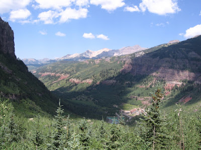
Looking back down the trail the high peaks on the northeast side of the Telluride Canyon are visible.


The Bridal Veil Creek has many small waterfalls along this segment and there is a waterfall joining the stream from the west.


I turned around after an additional 1.5 miles and 1:10 hours at a point where a sparkling creek crosses the trail. The additional elevation gain was another 700 feet to about 11,100 feet. 


I think this tumbling creek comes down from the Mud Lake basin. In late June there were several good patches of wildflowers along this segment of trail.


My return hike took 1:40 hours for a total hike of 4:10 hours for about 6.6 miles with 1900 feet of climbing. I carried and drank 3 liters of water on an 80 F degree late June day. It was a busy day in Telluride and there were many hikers and a few vehicles climbing to Bridal Veil Falls. 


(There is another post on Bridal Veil Falls that shows more of the hike leading up the switchback road. Use the labels to find.)

544544_$20 off any hotel booking of $350 or more with code TLSALE20 528669_Russell Womens Fleece Hoodie Banner

Saturday, June 4, 2011

Jud Wiebe Trail

The Jud Wiebe Trail is a 2.7 mile loop in Telluride town in southwest Colorado. The west trailhead is at the north end of Aspen Street. I parked in the free parking that is on the southwest side of town and it was a 20 minute walk through the scenic town streets to the trailhead.

The west trailhead is also the beginning of the short trail to Cornet Falls and to the east ends of the Deep Creek Trail and Sneffels Highline Trail. At the trailhead there is a bridge across Cornet Creek.
 

The first segment climbs steeply to the west through spruce, fir and aspens. There are increasingly higher views to the west down the Telluride Valley and across the town. It took me 0:35 minutes to climb to the trail junctions.

The Jud Wiebe Trail switches back toward the east and continues to climb. 


The views get better as the elevation increases. In early June there was still a lot of snow at the higher elevations.

At the high point there is a small bench with more spectacular views. It looks like the high point elevation is at about 9680 feet with the trailhead about 8800 feet.

 I thought the bench view point was higher than the top of the Bridal Veil Falls to the east. From the trail junctions it took 0:20 minutes more of climbing to arrive at the bench.

From the bench the trail begins to descend and winds around the Cornet Creek. This segment of trail still had some patches of snow. There is a bridge across the Cornet Creek and a trail junction with the Liberty Bell Trail.

The switchbacks down the final segment come very close to the area above the Cornet Falls but I didn’t see a good view of the falls from there. The east trailhead connects to Tomboy Road, which leads 5 miles to the Tomboy Mine site.
 

The Telluride Historical Museum on Gregory Street is very close to the east trailhead. The museum has interpretive displays on the mining and social history of Telluride and also has the Telluride Blanket, a rare Ancestral Pueblo woven blanket that is more than 700 years old.

My total hike from the parking area to the Museum took 2:30 hours for the 2.7 mile trail plus about 1 mile of town walking. It was a 58 F degree sunny day. I carried 2 liters of water and drank 1 of them.


528669_Russell Womens Fleece Hoodie Banner

Tuesday, June 9, 2009

Bear Creek Falls Trail

The Bear Creek Falls Trail is a popular 2.2 mile climb up along Bear Creek on the south side of Telluride Town in southwest Colorado.


The Trailhead is on the south end of Pine Street and is right off of the San Miguel River Trail that scenically flows through town.

I started my hike from the free parking lot on the southwest side of town and walked for 10 or 15 minutes along the River Trail before arriving at the Bear Creek Trail Head. There is an interpretive map of the trail posted near the Trail Head that describes some points of interest. The trail climbs a little more than 1000 feet.


There were quite a few hikers on the wide trail in early June, also joggers, dog walkers, families with children and one mountain biker. I’m always impressed in Telluride by how many nice looking dogs there are here, and how well behaved they all seem to be. Not mentioned on the interpretive map is the view of the in town beaver pond that is along the River Trail.


The forest along here is mostly Aspens and Engelmann Spruce and there are mountain views in both directions. Some of the points of interest are related to the mining era, but these are mostly sites without much remaining. The remains of a flume run across the trail and there are a few cables visible here and there.

Just below the falls one of the points of interest is called The Big Rock. Among the mountains visible back to the north along the trail are Greenback Mountain and St. Sophia’s Ridge.


Just before the Bear Creek Falls there is a trail junction with the Wasatch Trail for those who want to keep going higher. The Wasatch trail is a single track trail rather than an old road. It switchbacks steeply along a side creek for about 0.5 miles then turns south, still climbing but not as steeply.

The map I had showed a possible loop route off the Wasatch Trail into Mountain Village. Otherwise, the Wasatch Trail continues toward the Ophir area.


I went about one mile up the trail before running into snow patches that were somewhat hazardous without technical equipment and met two climbers who said it got worse further up, so I turned back. I was able to get across the snow patches pictured here but I did it awkwardly and didn’t like it.

The snow patches had flowing water below them and besides the danger of skidding several hundred yards down the steep slope, there was also a danger of a snow bridge collapsing.


From my starting point it took me 1:15 to reach the Bear Creek Falls and I continued about 1 mile further in another hour. Going down took me about 1:40 hours for a total hike of nearly 4 hours for about 7.5 miles.

Monday, June 23, 2008

Telluride Bike Trail

The Telluride Bike Trail runs along the north side of the Valley Floor west of Telluride in southwest Colorado, and connects to the Galloping Goose Trail and the River Trail near the junction with Highway 145.
Normally, a paved trail next to a highway wouldn't be a hikers choice, but the views in the Telluride Valley Floor are worth it and the Bike Trail completes a six mile loop with the River Trail on the south side of the canyon. The Bike Trail includes a tunnel under the spur route into Telluride town. Towards the west end of the trail the San Miguel River starts to come more into view.

The Valley Floor area was the subject of a development vs. conservation controversy that appears to have been settled in favor of conservation. I spotted a small group of elk along the trail that were taking a dip in the wetlands.
There is a bridge at west end that gives a good view up the canyon and over the river. My hike started here at the west end near Highway 145 and followed the 3 mile River Trail into town, then on to the free Gondola to Saint Sophia Station with the 2 mile hike down into Mountain Village on the Ridge Trail.
I returned to Telluride on the Gondola and hiked the 3 mile Bike Trail back to my starting point. This trip of about 8 miles took me about 4:45 hours.

Sunday, June 22, 2008

Telluride Ridge Trail to Mountain Village


The Telluride Ridge Trail is a 2 mile route between the St. Sophia Station of the Telluride Gondola and Mountain Village, the part of the Telluride Ski Area that doesn't fit into the main valley.


I started at the St. Sophia Station after riding the free Gondola up from Telluride Town. The Gondola station in town is right off the River Trail, offering some connectivity for an ongoing hike.
The Ridge Trail starts just under and to the right of the Gondola. At the same point there are ski roads leading back down to Telluride. There is a Nature Center at St. Sophia that has information on other trails on the mountain, and some activities for children.

The upper part of the trail is steep and rocky but offers some stunning views. Everyone I talked to said to watch out for mountain bikers rambling down hill.

The forest is very thick along the Ridge Trail with spruce, fir, and aspens. The trees are so thick that the mountain views are reduced to glimpses in some spots. The trail gets smoother and less steep lower down. The trail ends very near to the Mountain Village Gondola Station.

Mountain Village has what appears to be more of a European village architecture style, rather than the Victorian style that prevails in Telluride. The golf course is up here, saving the Valley Floor for open space. I rode the Gondola back up and then back down into Telluride Town.

Saturday, June 21, 2008

Telluride Valley Floor River Trail

The Valley Floor River Trail visits an area near Telluride in southwest Colorado that has been the subject of an intense legal battle in recent years between development and conservation.


I started my hike at the point where Colorado Highway 145 from the south makes a left turn to the west with the three mile spur into Telluride box canyon going to the east. This point is also a starting point for the Galloping Goose Trail and the Telluride Bike Trail.
 
The trail hugs the south side of the valley up against a steep slope thick with spruce, fir and aspen trees. Several small streams spill down to join the San Miguel, one of the few streams in Colorado without a dam on it. The story I gathered from internet sources is that in December of 1999, San Miguel Valley Corporation (SMVC) revealed updated plans for development on the Valley Floor.
These plans included a large hotel complex, a gondola link to the ski town Mountain Village which is just over the south ridge, an 18-hole golf course, commercial areas, condominiums, and single homes.  
On July 3, 2000, a public demonstration drew approximately 1,500 people to the County Courthouse steps for a Rally for the Valley, with participants roaring, “Free the Valley.” As reported by The Denver Post, “Dreadlocks cozied up to designer pants suits, movie stars linked up with ranch hands, tie-dyes connected to Ph.D.s, second-home owners gripped tent dwellers, tots hung on to retired miners. It must have been quite a scene.
Walking around town you see the odd mix drawn to this very scenic and trendy town, and I'm always impressed by the very nice looking dogs.

Some of the peaks of the Sneffels Wilderness Area are visible are visible as you stop and gaze along the river banks. There is the Telluride Bike Trail on the north side of the Valley that gives a view back toward the more heavily forested south side. The Bike Trail can be used to make a loop trip for both hikers and bikers.


On June 25, 2002, Telluride residents voted 609- 385 in a special election to pursue eminent domain for attainment of 570 acres on the south side of the Valley Floor to be placed under a conservation easement in perpetuity. The dispute was whether the town had the legal right to do this. After four months of deliberation, the Colorado Supreme Court ruled 6 – 1 in favor of the Town of Telluride in its long-standing effort to acquire the 570-acre gateway meadow known as the Valley Floor.

About one mile west of Telluride, the Boomerang Road descends from the area near the golf course and makes a junction with the Valley Floor River Trail.


This is a steep old road passing through the Spruce-Fir Forest. At the top of the Boomerang Road, there are some good views toward the mountains that are directly across. I took about 1:15 to complete the three mile walk. Once in the town of Telluride you will probably want to continue on the in town part of the River Trail.


In the in town part of the River Trail here has been an ongoing project for restoring the natural habitats of the San Miguel River below that have been damaged over the years by mining and resort development. Improved aquatic habitat in the river channel by creating a variety of natural appearing features including riffles-pools-glides and in stream cover.


Sunday, November 11, 2007

Bridal Veil Falls Trail at Telluride

Bridal Veil Falls is just to the east of Telluride town, in southwest Colorado. It is one of four waterfalls visible in the Telluride area, and is a popular destination.


It's possible to drive to the top of the falls with  4WD. I started my hike in the free parking at the southwest end of town and walked along the San Miguel River Trail, a strip of clear running mountain stream winding between the ski lodges, condos, and sports shops, past a beaver pond and through the town park and camp ground.


At the east end of town the river trail merges with the Idarado Legacy Trail, a segment with interpretive signs that point out the mining history of Telluride.


Past the old mill, a rough steep road, surrounded by towering peaks, climbs by switchbacks up towards the falls.


It is possible to drive through town to trailhead parking and start 1.2 miles from the base of the falls, or 1.8 miles to the top. Along the way there are also some views of Ingram Falls.

From a distance, it looks like there is a building up above the falls. What can that be, way up there? The historic markers point out that the building is a power plant, originally built in 1907 to supply power for mining operations. After a checkered history, the plant has been restored and is currently producing current.

One of the switchbacks bends back right at the base of the falls, a light mist blowing off the water tumbling about 365  feet.

It took me 2:30 hours to get up to the power plant from the west end of town, spending part of the time dodging 60 or so crazed dirt bike riders ripping down the rough road on a multi day mountain tour. At the top it is possible to continue on Black Bear Road toward Ingram Falls, or toward Blue Lake and Bridal Veil Basin.

On the return hike, I took advantage of the free summer gondola rides from Telluride Station, taking off from right along the River Trail up to Mountain Village, a Telluride suburb that doesn't fit in the the Victorian themed valley.
The gondola has a stop at Station St. Sophia, a scenic trail head with a nature center, and then descends down into the upscale Mountain Village area. The Mountain Village area has more ski lodges, condos, lifts, and sports shops, and the golf course is up there, next to a lot of nice looking houses.

532497_120 x 90 Starting Salary $42k. Group 1 528614_Russell Outdoor Logo 125x125 18407_$5 Shipping on Orders of $99 or More!