Tuesday, June 26, 2012

Above Bridal Veil Falls


Bridal Veil Falls is a popular hiking destination located at the east end of the Telluride Canyon and east of Telluride town. At 365 feet it is the longest free falling waterfall in Colorado. There is trailhead parking at the base of the switchback road just past the Pandora Mill.


From the parking area it is 1.2 miles to the base of the falls and 1.8 miles to the historic power plant at the top. The starting elevation is about 9200 feet at it is about 10,400 feet at the top.


It took me 0:55 minutes to arrive at the base of the falls and 1:30 hours to reach the top. 


The old road continues into the Bridal Veil Basin behind the historic power plant. Vehicles driving to the top are blocked from continuing. The other hiking option at the top of the falls is to continue on the Black Bear Road toward Ingram Falls. 


The trail continues to climb as steeply as on the switchback road that leads to the waterfall, with several high peaks and forested hillsides visible.


Looking back down the trail the high peaks on the northeast side of the Telluride Canyon are visible.


The Bridal Veil Creek has many small waterfalls along this segment and there is a waterfall joining the stream from the west.


I turned around after an additional 1.5 miles and 1:10 hours at a point where a sparkling creek crosses the trail. The additional elevation gain was another 700 feet to about 11,100 feet. 


I think this tumbling creek comes down from the Mud Lake basin. In late June there were several good patches of wildflowers along this segment of trail.


My return hike took 1:40 hours for a total hike of 4:10 hours for about 6.6 miles with 1900 feet of climbing. I carried and drank 3 liters of water on an 80 F degree late June day. It was a busy day in Telluride and there were many hikers and a few vehicles climbing to Bridal Veil Falls. 


(There is another post on Bridal Veil Falls that shows more of the hike leading up the switchback road. Use the labels to find.)

544544_$20 off any hotel booking of $350 or more with code TLSALE20 528669_Russell Womens Fleece Hoodie Banner

Sunday, May 27, 2012

Black Canyon of the Gunnison Overlook Trails


The Black Canyon of the Gunnison National Park in southwest Colorado has nine short trails to overlook points between the south rim Visitor Center and Warner Point at the end of the Rim Rock Drive. Seven of the short overlook trails have the one way distance in yards posted.

Adding up all the distances, I got about 4000 total yards, or about 2.3 miles of walking to see all the overlooks. Some of the interpretive signs in the Visitor Center are repeated along the trails, explaining the overwhelming scenery.


At the Pulpit Rock Overlook there is discussion of how the Black Canyon is shaped. The north rim is much steeper than the north facing south rim. 


The next three overlooks are nearly side by side. Cross Fissures, Rock Point, and Devils Overlook are relatively long with Devils Overlook the longest at 607 yards.


In this area you can see some of the Pegmatite Dikes. Molten Pegmatite rocks have squeezed into the cracks to form lighter colored bands. The lighter bands of rock contain the common minerals of Mica, Feldspar, Quartz, and Garnet.


The Narrows, between Pulpit Rock and Chasm View is the shallowest and narrowest section of the Canyon.  This area was very difficult for early surveyors to pass. Interpretive information says that the canyon width at Chasm View is 1100 feet and 1820 feet deep. The Gunnison River has a very steep gradient, averaging 95 feet per mile, giving the river the energy to cut downwards.


The Painted Wall is probably the most dramatic of the view points. This is the highest cliff in Colorado at 2300 feet. The patterns here were created more than one billion years ago as molten rock squeezed into existing rock. These cliff overlooks are good places to see the White-throated Swifts and the Violet-green Swallows.


The Cedar Point View Point has more views of the Painted Wall and also has small signs identifying many of the common plants. This area has more Pinyon Pine and Juniper trees than the area closer to the Visitor Center.


Dragon Point also has views of the Painted Wall and a good view down the Black Canyon. 


Sunset View doesn't have a trail long enough to be concerned about the distance. On a clear day Monument Mesa and Grand Mesa are visible in the distance. The last viewpoint is at High Point where the 1.4 mile Warner Point Trail is located. It took me 2:30 hours to visit all these view points.

Advice from the Black Canyon: Carve out a place for yourself. Aspire to new plateaus. Stand the test of time. Don’t get boxed in. Listen to the voice of the wind. It’s OK to be a little off the wall. Reach Deep!


528614_Russell Outdoor Logo 125x125

Saturday, May 26, 2012

Rim Rock Trail and Uplands Trail-Black Canyon of the Gunnison


The Rim Rock Trail and Uplands Trail both connect the south rim Visitor Center and the campground at Black Canyon of the Gunnison National Park in southwest Colorado. The total loop is about 2.5 miles.


I started on the 1 mile Rim Trail that departs from the parking area of the Visitor Center. After about 0.5 miles along the rim, the trail passes Tomichi Point, the first view area along the Rim Drive on the way to the Visitor Center.

Continuing south of Tomichi Point, there is an interpreted trail segment with 14 stops. Arriving from the Visitor Center, the stops begin with No. 14.


The Trail Guide doesn’t identify specific features but talks more in general about observing and listening to the environment. There are general comments about which plants and animals live here and also about the erosion process that has formed the Black Canyon. The Tomichi Route into the deep canyon begins near marker No. 13, but wasn’t otherwise marked.


Near the campground, there is a marked junction with the 1.5 mile Uplands Trail. This segment returns to the Visitor Center through mostly Gambel Oak, Sagebrush, and Utah Serviceberry, and is easy walking but without any more views into the Black Canyon.


The trail crosses the paved road twice before making a junction with and finishing on the Oak Flats Trail near the Visitor Center. My hike on the Rim and Uplands Trails took 1:10 hours on a 80 F degree late May day.

Friday, May 25, 2012

Oak Flats Trail-Black Canyon of the Gunnison


The Oak Flats Trail is a 2 mile loop that begins at the south rim Visitor Center of Black Canyon of Gunnison National Park in southwest Colorado.


Before starting on the trail most visitors will probably get a preview of the Black Canyon at the Gunnison Point Overlook. The Black Canyon features very old dark colored pre-Cambrian basement rocks that have been penetrated with lighter colored veins or Pegmatite Dikes.


The upper segment of trail passes through Gambel Oak forest with many Utah Serviceberry shrubs. In late May the Serviceberries were exploding with flowers. At the loop junction I stayed right for a counter-clockwise loop.


Staying right leads to a steep descent down switchbacks to another trail junction that leads to a permit required river access trail. This is the Gunnison Route, one of three on the south rim. The other routes are the Tomichi Route on the nearby Rim Trail and the Warner Route on the Warner Point Trail.


Continuing on the main trail, there are Douglas Firs in the shady areas and views across to the cliffs with occasional glimpses of the Gunnison River.


The climb back up is more gradual that going down. On the return segment there is a trail junction with the Uplands Trail that leads to the campground area. My hike on the Oak Flats Trail took 0:50 minutes.

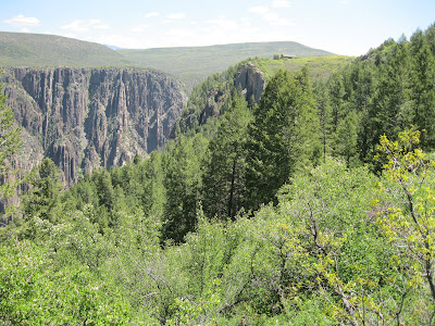
Warner Point Trail-Black Canyon of the Gunnison


The Warner Point Trail is a 1.4 mile round trip that begins at the High Point view point at the end of the south rim road at Black Canyon of the Gunnison National Park in southwest Colorado. The trail honors Mark Warner who came to western Colorado in 1917 and campaigned to preserve the Black Canyon for future generations.


There is a 14 stop trail guide for the Warner Point Trail and there are views to the south toward the Mount Sneffels area of the San Juan Mountains.


One of the interpretive signs at the High Point discusses the Gunnison uplift, the subsequent erosion, the volcanic activity in the West Elk and San Juan Mountains, and how the Gunnison River cut across the buried uplift to cut the Black Canyon.


One of the largest Pinyon Pines that you’ll ever find is at trail marker 13. The trail guide says that some of the trees in this grove are 750 to 850 years old. There are also some Douglas Firs growing on the cooler north side of this ridge. One of the three south rim trails that descends into the Black Canyon begins along the Warner Point Trail at an obscure marker.


There is a view point at the end of the trail into the Black Canyon. Mark Warner’s efforts were rewarded when President Herbert Hoover signed the Black Canyon as a National Monument in 1933. President Clinton expanded the park and renamed it as a National Park in 1999.


I spent 0:50 minutes on the Warner Point Trail on an 80 F degree late May afternoon.

528614_Russell Outdoor Logo 125x125